Free Web Submission http://addurl.nu FreeWebSubmission.com Software Directory www britain directory com education Visit Timeshares Earn free bitcoin http://www.visitorsdetails.com CAPTAIN TAREK DREAM: April 2021

Wednesday, April 14, 2021

Volcanoes and active lava, beginning of 2021, astonished the world براكين و حمم بركانية نشطة بداية 2021 آثارت دهشة العالم


6 براكين نشطوا مع بداية 2021.. صور لحمم بركانية آثارت دهشة العالم

6 active volcanoes by the beginning of 2021 ... Pictures of lava that astonished the world

نشطت العديد من البراكين فى أمريكا وآسيا وأوروبا في النشاط حتى الآن هذا العام، ترك البعض منهم سجلات مثيرة للإعجاب من الحفر الضخمة المغطاة بالحمم البركانية وسحب الرماد لعدة كيلومترات، وبلغ عدد البراكين التى استعادت نشاطها إلى 6 براكين.

Many volcanoes in America, Asia and Europe have been active so far this year, some of them left impressive records of huge pits covered with lava and clouds of ash for several kilometers, and the number of volcanoes that have recovered reached 6.

بركان كيلاوى فى هاواى

تصاعدت أعمدة الدخان من بركان كيلاوي في جزيرة هاواي الأمريكية، أحد أنشط البراكين في العالم. 

Kilauea volcano in Hawaii

بركان هاواى

Hawaiian volcano

Plumes of smoke billowed from Kilauea volcano on the American island of Hawaii, one of the most active in the world.

ويقول الخبراء، إن البركان يثور باستمرار منذ عام 1983 غير أن تصاعد أعمدة الدخان الذي نتج عن الرياح الشديدة والرطوبة العالية يعد أمرا نادرا، وكان ثار فى يناير الماضى.

Experts say that the volcano has been erupting continuously since 1983, but the plumes of smoke that resulted from strong winds and high humidity are rare, and it erupted in January.

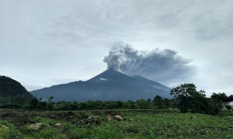
بركان لا سوفرير سان فينيست

Volcan La Soufriere-Saint-Finistère

أدى انفجار بركان لا سوفريير الثانى في سانت فنسنت إلى ترك الجزيرة الكاريبية بدون كهرباء وتحت سحابة كثيفة من الرماد، وثار بركان "لا سوفرير" لأول مرة يوم الجمعة، 9 أبريل، ما أدى إلى تغطية الجزيرة بطبقة من الرماد وأجبر نحو 16 ألف شخص على إخلاء منازلهم، حسبما قالت شبكة سى إن إن على نسختها الإسبانية.

The second eruption of La Soufriere volcano in St. Vincent left the Caribbean island without electricity and under a thick cloud of ash. The volcano "La Soufriere" erupted for the first time on Friday, April 9th, covering the island with a layer of ash and forcing about 16,000 people to evacuate Their homes, CNN said on its Spanish version.

بركان سان فينيست

San Finister volcano

طبقة من الرماد غطت جزيرة سانت فينسنت بشرق الكاريبي وانتشرت رائحة "كبريت قوية" في الهواء السبت بعد يوم من ثوران بركان كان خاملا لعقود.

A layer of ash covered the eastern Caribbean island of St. Vincent and the smell of "strong sulfur" spread into the air Saturday, the day after an eruption of a volcano that had been idle for decades.

وأدى ثوران بركان لا سوفرير إلى تصاعد سحب من الرماد لارتفاع نحو 10 كيلومترات، مما أدى إلى إجلاء بعض السكان في المناطق القريبة.

The eruption of La Soufriere volcano sent clouds of ash up to about 10 km, which led to the evacuation of some residents in nearby areas.

وقال رئيس الوزراء رالف جونسالفيس، إنه لم يتضح مقدار الرماد الذي سينطلق من البركان. وأضاف أن ما يربو على 3200 شخص يعيشون الآن في الملاجئ.

Prime Minister Ralph Gonçalves said it was not clear how much ash would be released from the volcano. He added that more than 3,200 people were now living in shelters.

ولم تشهد سانت فينسنت وجرينادين، التي يبلغ عدد سكانها ما يربو قليلا على 100 ألف نسمة، نشاطا بركانيا منذ عام 1979، عندما تسبب ثوران بركاني في خسائر تقدر بنحو 100 مليون دولار. وأدى ثوران بركان لا سوفرير في عام 1902 إلى مقتل ما يزيد على 1000 شخص.

Saint Vincent and the Grenadines, which have a population of just over 100,000, have not experienced volcanic activity since 1979, when a volcanic eruption caused losses estimated at $ 100 million. The eruption of La Soufriere volcano in 1902 killed more than 1,000 people.

أيسلندا

Iceland

وقال مكتب الأرصاد الجوية في أيسندا، إن بركانا ثار في شبه جزيرة ريكيانيس بجنوب غرب أيسلندا بداية أبريل في أعقاب آلاف الزلازل الصغيرة في المنطقة في الأسابيع الأخيرة، وتعد شبه الجزيرة الواقعة جنوب غرب العاصمة ريكيافيك بؤرة زلزالية ساخنة حيث شهدت ما لا يقل عن 40 ألف زلزال في الأسابيع الأخيرة.

The Meteorological Office in Iceland said that a volcano erupted in the Reykjanes Peninsula in southwestern Iceland in early April following thousands of small earthquakes in the region in recent weeks. In recent weeks.

بركان ايسلندا

Iceland volcano

وقال مكتب الأرصاد الجوية على تويتر: "بدأ ثوران بركاني في فاجرادالسفيال" مشيرا إلى جبل يقع على بعد نحو 30 كيلومترا جنوب غربي العاصمة، وأظهرت صور على مواقع إلكترونية لوسائل إعلام محلية توهج السماء خلال الليل بلون أحمر، وقال المكتب لرويترز، إن حركة الطيران من وإلى مطار كيفلافيك الدولي توقفت.

The Met Office said on Twitter: "A volcanic eruption has started in Fajrad Alsafiyal," pointing to a mountain located about 30 kilometers southwest of the capital. Pictures on local media websites showed the sky glowing during the night in a red color. The office told Reuters that air traffic from And to Keflavik International Airport I stopped.

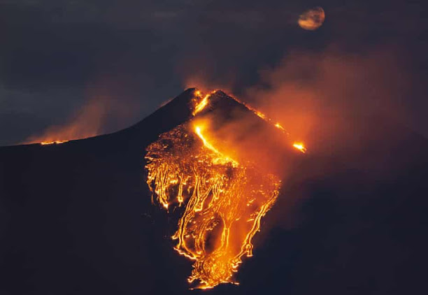
بركان إتنا

Etna volcano

أطلق بركان "إتنا"، عمودا من الحمم البركانية يبلغ ارتفاعه 6 كيلومترات، في أحدث سلسلة من الانفجارات المذهلة من أعلى بركان نشط في أوروبا، حسبما قالت وكالة "أنسا" الإيطالية.

The volcano "Etna" released a column of lava 6 km high, in the latest series of astonishing eruptions from the highest active volcano in Europe, Italian news agency ANSA said.

وأشارت الوكالة إلى أن البركان أطلق الرماد على كاتانيا القريبة، لكن مطار مدينة صقلية الشرقية كان لا يزال يعمل، وساعد النسيم الجنوبي الشرقي في نقل العمود العالي والكثيف من الرماد الحجري عبر المدينة.

The agency noted that the volcano released ash into nearby Catania, but the airport in the eastern city of Sicily was still operating, and the southeast breeze helped transport the high and dense column of stone ash across the city.

بركان ايتنا

Aetna volcano

وسقطت الحمم أيضا على عدد من البلدات والقرى الأصغر على المنحدرات الجنوبية لإيتنا، بما في ذلك نيكولوسي وتريكاستاني وبيدارا وأسي سانت أنتونيو وسان جريجوريو. كما أطلق البركان تدفقا جديدا للحمم البركانية.

The lava also fell on a number of smaller towns and villages on the southern slopes of Aetna, including Nikolosi, Tricastani, Bidara, Asi Sant'Antonio and San Gregorio. The volcano also released a new lava flow.

وقال معهد علم البراكين INGV، إنها كانت "النوبة الثانية عشرة" في أحدث مرحلة من النشاط البركاني لإتنا، والتي بدأت في منتصف فبراير.

The Institute of Volcanology, INGV, said it was the "twelfth bout" in the latest phase of Etna's volcanic activity, which began in mid-February.

وكان فى 3 مارس ثار البركان، وأدى إلى سحابة رمادية أجبرت على تعليق عمليات الطيران فى مطار كاتنايا، على الساحل الشرقى لصقلية، ونظرا للنشاط البركانى لإيتنا ونتيجة للرماد البركانى الغزير، وتم إغلاق مدرج مطار كاتانيا، ويتم تنفيذ أنشطة التنظيف.

On March 3, the volcano erupted, and led to a gray cloud that forced the suspension of flight operations at Catnaya airport, on the eastern coast of Sicily, and due to the volcanic activity of Aetna and as a result of heavy volcanic ash, the runway of Catania airport was closed, and cleaning activities are carried out.

ووفقًا لخدمات الطوارئ الإيطالية، بدأت الحفرة الواقعة في جنوب شرق الجبل، الواقعة في Valle del Bove، في إطلاق الرماد وتدفقات الحمم البركانية التي وصلت إلى بلديات كاتانيا ونيكولوسي والمناطق المحيطة الأخرى.

According to the Italian emergency services, the crater in the southeast of the mountain, located in Valle del Bove, began to release ash and pyroclastic flows that reached the municipalities of Catania, Nicolosi and other surrounding areas.

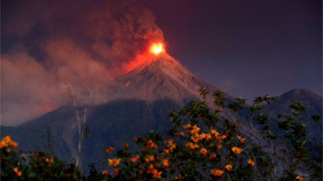
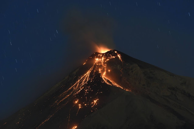
جواتيمالا

Guatemala

أغلقت جواتيمالا مطارها الدولي الوحيد بسبب تساقط الرماد الذي تسبب به ثوران بركان باكايا شبه الدائم، وتغير اتجاه الرياح من جنوبية إلى شمالية، بحسب ما أعلنه مسؤولون.

Guatemala closed its only international airport due to ash fall caused by the semi-permanent eruption of the Pacaya volcano, and the winds changed from southerly to northerly, officials said.

ويرتفع البركان على علوّ 2500 متر تقريباً عن سطح البحر، كما يبعد بنحو 25 كيلومترا عن جواتيمالا سيتي، ووصلت حممه ورماده قريباً من مناطق مأهولة بالسكان.

The volcano is about 2,500 meters above sea level, 25 kilometers from Guatemala City, and its lava and ash reached close to populated areas.


لم تكشف السلطات عن عدد الأشخاص المتأثرين بإغلاق المطار، فيما قالت إنها ستراقب عن كثب النشاط البركاني والتجمعات السكانية القريبة من باكايا. مع ذلك لم تدعُ السلطات إلى إجراء عمليات إجلاء واسعة حتى الآن.

The authorities did not disclose the number of people affected by the airport closure, while they said that they would closely monitor volcanic activity and communities near Pakaya. However, the authorities have not called for large-scale evacuations yet.

وكان ثوران البركان في 2010 قد أدى إلى مقتل مراسل تليفزيون خلال عملية تغطية مباشرة. وفي جواتيمالا الواقعة في أمريكا الوسطى نحو 30 بركاناً بينها بركانان نشيطان.

The volcano eruption in 2010 killed a TV reporter during a live coverage operation. In Guatemala, located in Central America, about 30 volcanoes, including two active volcanoes.

بركان سينابونج بأندونيسيا

Sinabung volcano, Indonesia

بدأ بركان جبل سينابونج ثورانه في إقليم سومطرة الشمالية بإندونيسيا، حيث أطلق مواد بركانية وعمود رماد وصل ارتفاعه إلى حوالي 5 كيلومترات، وذلك منذ شهر تقريبا.

Mount Sinabung volcano began its eruption in North Sumatra, Indonesia, when it released volcanic materials and an ash column about 5 km high, about a month ago.

بركان اندونيسا

Volcano of Indonesia


بركان اندونيسا

Volcano of Indonesia

ويثور بركان جبل سينابونج بشكل دوري منذ سبتمبر 2013، ما تسبب في نزوح عشرات الآلاف من الناس.

Mount Sinabung volcano has been erupting periodically since September 2013, causing tens of thousands of people to be displaced.

Friday, April 9, 2021

Discovery of 'Lost Golden City' in Luxor إكتشاف المدينة الذهبية المفقودة في الأقصر

زاهي حواس يعلن عن اكتشاف المدينة الذهبية المفقودة في الأقصر

اكتشفت البعثة المصرية برئاسة الدكتور زاهي حواس وزير الآثار الأسبق والمشتركة بين مركز الدكتور زاهي حواس للمصريات التابع لمكتبة الإسكندرية والمجلس الأعلى للآثار "المدينة المفقودة تحت الرمال والتي كانت تسمى "صعود آتون" والتي يعود تاريخها إلى عهد الملك أمنحتب الثالث، واستمر استخدام المدينة من قبل توت عنخ آمون، اي منذ 3000 عام.

وقال الدكتور" زاهي حواس" ان العمل بدأ في هذه المنطقة للبحث عن المعبد الجنائزي الخاص بالملك توت عنخ آمون، لأنه تم العثور على معبدي كل من "حورمحب" و"آي" من قبل".

وأكد "حواس" ان البعثة عثرت علي أكبر مدينة على الإطلاق في مصر والتي أسسها أحد أعظم حكام مصر وهو الملك "أمنحتب الثالث" الملك التاسع من الأسرة الثامنة عشر، الذي حكم مصر من عام 1391 حتى 1353 ق.م. وقد شاركه ابنه ووريث العرش المستقبلي أمنحتب الرابع " أخناتون" آخر ثمان سنوات من عهده. 

وأضاف "حواس" ان هذه المدينة هي أكبر مستوطنة إدارية وصناعية في عصر الإمبراطورية المصرية على الضفة الغربية للأقصر، حيث عثر بالمدينة على منازل يصل ارتفاع بعض جدرانها إلى نحو ٣ أمتار ومقسمة إلى شوارع.

وتابع "حواس" لقد كشفنا عن جزء من المدينة يمتد غربا، بينما يعد دير المدينة جزء من مدينتنا". 

وبدأت أعمال التنقيب في سبتمبر 2020، وفي غضون أسابيع، بدأت تشكيلات من الطوب اللبن بالظهور في جميع الاتجاهات، وكانت دهشة البعثة الكبيرة، حينما اكتشفت أن الموقع هو مدينة كبيرة في حالة جيدة من الحفظ، بجدران شبه مكتملة، وغرف مليئة بأدوات الحياة اليومية، وقد بقيت الطبقات الأثرية على حالها منذ آلاف السنين، وتركها السكان القدماء كما لو كانت بالأمس.

وقالت الدكتورة "بيتسي بريان"، أستاذة علم المصريات بجامعة جون هوبكنز، إن اكتشاف هذه المدينة المفقودة هو ثاني اكتشاف أثري مهم بعد اكتشاف مقبرة توت عنخ آمون.

وإن اكتشاف هذه المدينة، لم يمنحنا فقط لمحة نادرة عن حياة قدماء المصريين في عصر الامبراطورية، ولكنه أيضاً سيساعدنا في إلقاء الضوء على أحد أعظم الألغاز في التاريخ ولماذا قرر إخناتون ونفرتيتي الانتقال إلى العمارنة؟!

وتقع منطقة الحفائر بين معبد رمسيس الثالث في مدينة هابو ومعبد أمنحتب الثالث في ممنون.

 وقد بدأت البعثة المصرية العمل في هذه المنطقة بحثا عن معبد توت عنخ آمون الجنائزي، وكان الملك آي، خليفة توت عنخ آمون هو من قام ببناء معبده على موقع تم تجاوره لاحقًا على جانبه الجنوبي بمعبد رمسيس الثالث في مدينة هابو.

وكان الهدف الأول للبعثة هو تحديد تاريخ هذه المدينة، حيث تم العثور على نقوش هيروغليفية على أغطية خزفية لأواني النبيذ، وتخبرنا المراجع التاريخية أن المدينة كانت تتألف من ثلاثة قصور ملكية للملك أمنحتب الثالث، بالإضافة إلى المركز الإداري والصناعي للإمبراطورية. 

وقد أكد عدد كبير من الاكتشافات الأثرية على تاريخ المدينة مثل الخواتم والجعارين والأواني الفخارية الملونة والطوب اللبن الذي يحمل أختام خرطوش الملك أمنحتب الثالث، وبعد سبعة أشهر فقط من التنقيب، تم الكشف عن عدة مناطق أو أحياء بتلك المدينة.

وعثرت البعثة في الجزء الجنوبي على المخبز ومنطقة الطهي وأماكن إعداد الطعام كاملة مع الأفران وأواني التخزين الفخارية، والذي كان يخدم عددًا كبيرًا من العمال والموظفين.

أما المنطقة الثانية، والتي تم الكشف عنها جزئيًا وهي تمثل الحي الإداري والسكني حيث تضم وحدات أكبر ذات تنظيم جيد. وهذه المنطقة مسيجة بجدار متعرج، مع نقطة دخول واحدة فقط تؤدي إلى ممرات داخلية ومناطق سكنية. وهذا المدخل الوحيد يجعلنا نعتقد أنه كان نوعًا من الأمن حيث القدرة على التحكم في الدخول والخروج إلى المناطق المغلقة.

وتعتبر الجدران المتعرجة من العناصر المعمارية النادرة في العمارة المصرية القديمة، وقد استخدمت بشكل أساسي في نهاية الأسرة الثامنة عشر.

أما المنطقة الثالثة فهي ورشة العمل، حيث تضم بإحدى جهاتها منطقة إنتاج الطوب اللبن المستخدم لبناء المعابد والملحقات، ويحتوي الطوب على أختام تحمل خرطوش الملك أمنحتب الثالث (نب ماعت رع). 

وتم اكتشاف عدد كبير من قوالب الصب الخاصة بإنتاج التمائم والعناصر الزخرفية الدقيقة، وهذا دليل آخر على النشاط الواسع في المدينة لإنتاج زخارف كل من المعابد والمقابر.

وعثرت البعثة في جميع أنحاء مناطق الحفائر على العديد من الأدوات المستخدمة في النشاط الصناعي مثل أعمال الغزل والنسيج، كما تم اكتشاف ركام المعادن والزجاج، لكن المنطقة الرئيسية لمثل هذا النشاط لم يتم اكتشافها بعد.

كما تم العثور على دفنتين غير مألوفتين لبقرة أو ثور داخل إحدى الغرف، ومازال البحث جار لتحديد طبيعة والغرض من هذه الدفنات

كما تم العثور على دفنة رائعة لشخص ما بذراعيه ممدودتين إلى جانبه، وبقايا حبل ملفوف حول ركبتيه، ويعد موقع ووضع هذا الهيكل العظمي غريب نوعًا ما، وهناك المزيد من البحث حول هذا الأمر. 

كما تم العثور على إناء يحتوي على جالونين من اللحم المجفف أو المسلوق (حوالي 10 كجم) ويحمل نقوش قيمة يمكن قراءتها: "السنة 37، لحوم مسلوقة لعيد حب سد الثالث من جزارة حظيرة "خع" التي صنعها الجزار إيوي". 

وهذه المعلومات القيمة لا تعطينا فقط اسمي شخصين كانا يعيشان ويعملان في المدينة، بل يؤكدان أن المدينة كانت نشطة وتحدد زمن مشاركة الملك أمنحتب الثالث مع ابنه أخناتون.

كما عثرت البعثة أيضاً على نص منقوش على طبعة ختم يقرأ: "جم با أتون" أي مقاطعة أتون الساطع، وهذا اسم معبد قد بناه الملك أخناتون بالكرنك. 

كما تم الكشف عن مقبرة كبيرة لم يتم تحديد مداها بعد، واكتشفت البعثة مجموعة من المقابر المنحوتة في الصخور بأحجام مختلفة والتي يمكن الوصول إليها من خلال سلالم منحوتة في الصخر، وهناك سمة مشتركة لبناء المقابر في وادي الملوك ووادي النبلاء. ومازال العمل جار وتتوقع البعثة الكشف عن مقابر لم تمسها يد مليئة بالكنوز. 

وتتيح أعمال التنقيب المستمرة لعلماء الآثار الوصول إلى طبقة النشاط الأصلية للمدينة، حيث تم كشف النقاب عن معلومات ستغير التاريخ وتعطينا نظرة ثاقبة فريدة عن عائلة توت عنخ آمون. 

كما سيقدم لنا اكتشاف المدينة المفقودة أيضًا فهمًا أعمق للحياة اليومية للمصريين القدماء من حيث أسلوب بناء وديكورات المنازل والأدوات التي استخدموها وكيفية تنظيم العمل. وقد تم الكشف عن ثلث المنطقة فقط حتى الآن، وستواصل البعثة أعمال التنقيب، بما في ذلك المنطقة التي تم تحديدها على أنها الموقع المحتمل لمعبد توت عنخ آمون الجنائزي. 

واختتم "حواس" لدينا الكثير من المعلومات حول المقابر والمعابد ولكن هذه هي المرة الأولى التي تكشف أسرارًا عن حياة ملوك العصر الذهبي لمصر.

Zahi Hawass Announces Discovery of 'Lost Golden City' in Luxor

The Egyptian mission under Dr. Zahi Hawass found the city that was lost under the sands and called: The Rise of Aten. The city is 3000 years old, dates to the reign of Amenhotep III, and continued to be used by Tutankhamun and Ay.

‘Many foreign missions searched for this city and never found it. We began our work searching for the mortuary temple of Tutankhamun because the temples of both Horemheb and Ay were found in this area’  Hawass said.

The Egyptian expedition was surprised to discover the largest city ever found in Egypt. Founded by one of the greatest rulers of Egypt, king Amenhotep III, the ninth king of the 18th dynasty who ruled Egypt from 1391 till 1353 B.C, this city was active during the great king’s co-regency with his son, the famous Amenhotep IV/Akhenaton.

It was the largest administrative and industrial settlement in the era of the Egyptian empire on the western bank of Luxor.

‘The city’s streets are flanked by houses, which some of their walls are up to3 meters high,' Hawass continued, ‘we can reveal that the city extends to the west, all the way to the famous Deir el-Medina.'

Betsy Brian, Professor of Egyptology at John Hopkins University in Baltimore USA, said ‘The discovery of this lost city is the second most important archeological discovery since the tomb of Tutankhamun”.

"The discovery of the Lost City, not only will give us a rare glimpse into the life of the Ancient Egyptians at the time where the Empire was at his wealthiest but will help us shed light on one of history's greatest mystery: why did Akhenaten & Nefertiti decide to move to Amarna," Brian added.

The excavation area is sandwiched between Rameses III's temple at Medinet Habu and Amenhotep III's temple at Memnon. The Egyptian mission started working in this area in search of Tutankhamun's Mortuary Temple.

Tutankhamun's successor, King Ay, built his temple on a site which was later adjoined on its southern side by Rameses III's temple at Medinet Habu.

Egyptologists believe Ay's temple may formerly have belonged to Tutankhamun as two colossal statues of the young king were found there. The northern part of the temple is still under the sands.

The excavation started in September 2020 and within weeks, to the team's great surprise, formations of mud bricks began to appear in all directions. What they unearthed was the site of a large city in a good condition of preservation, with almost complete walls, and with rooms filled with tools of daily life.

The archaeological layers have laid untouched for thousands of years, left by the ancient residents as if it were yesterday.

The first goal of the mission was to date this settlement. Hieroglyphic inscriptions found on clay caps of wine vessels. Historical references tell us the settlement consisted of three royal palaces of King Amenhotep III, as well as the Empire's administrative and industrial center.

A large number of archaeological finds, such as rings, scarabs, colored pottery vessels, and mud bricks bearing seals of King Amenhotep III's cartouche, confirmed the dating of the city.

After only seven months of excavation, several areas or neighborhoods have been uncovered.

In the southern part, the mission found a bakery, a cooking and food preparation area, complete with ovens and storage pottery. From its size, we can state the kitchen was catering a very large number of workers and employees.

The second area which is still partly uncovered, is the administrative and residential district, with larger and well-arranged units.

This area is fenced in by a zigzag wall, with only one access point leading to internal corridors and residential areas. The single entrance makes us think it was some sort of security, with the ability to control entry and exit to enclosed areas.

Zigzag walls are one of the rare architectural elements in ancient Egyptian architecture, mainly used towards the end of the 18th Dynasty. The third area is the workshop.

On one side, the production area for the mud bricks used to build temples and annexes. The bricks have seals bearing the cartouche of King Amenhotep III (Neb Maat Ra).

On the other, a large number of casting molds for the production of amulets and delicate decorative elements. This is further evidence of the extensive activity in the city to produce decorations for both temples and tombs.

All over the excavated areas, the mission has found many tools used in some sort of industrial activity like spinning and weaving.

Metal and glass-making slag has also been unearthed, but the main area of such activity has yet to be discovered.

Two unusual burials of a cow or bull were found inside one of the rooms. Investigations are underway to determine the nature and purpose of this practice.

And even more remarkable burial of a person found with arms outstretched to his side, and remains of a rope wrapped around his knees. The location and position of this skeleton are rather odd, and more investigations are in progress.

One of the most recent finds of a vessel containing 2 gallons of dried or boiled meat (about 10 kg), has a valuable inscription: Year 37, dressed meat for the third Heb Sed festival from the slaughterhouse of the stockyard of Kha made by the butcher luwy.

This valuable information, not only gives us the names of two people that lived and worked in the city but confirmed that the city was active and the time of King Amenhotep III's co-regency with his son Akhenaten.

The excavation also reveals a mud seal with inscriptions that can be read: “gm pa Aton” that can be translated as “ the domain of the dazzling Aten”, this is the name of a temple built by King Akhenaten at Karnak.

As history goes, one year after this pot was made, the city was abandoned and the capital relocated to Amarna. But was it? And why? And was the city repopulated again when Tutankhamun returned to Thebes?

Only further excavations of the area will reveal what truly happened 3500 years ago.


To the north of the settlement a large cemetery was uncovered, the extent of which has yet to be determined.

So far, the mission has discovered a group of rock-cut tombs of different sizes that can be reached through stairs carved into the rock. A common feature of tomb construction in the Valley of the Kings and in the Valley of the Nobles.


Work is underway and the mission expects to uncover untouched tombs filled with treasures.